Wetherburn's Stable (Garage) Archaeological Report, Block 9 Building 41C Lot 00Originally entitled: "Wetherburn's Stable Block 9"
Colonial Williamsburg Foundation Library Research Report Series - 1183
Colonial Williamsburg Foundation Library
Williamsburg, Virginia
1990
WETHERBURN'S STABLE
BLOCK 9
This briefing was prepared in order to determine what documentary evidence exists for a stable on the southwest corner of Colonial Lot 20 and to assess the results of past archaeological investigations in this area and what potential remains for further archaeological evidence on the property.
There is documentary evidence for a stable on either Colonial Lot 20 or 21 during the 18th century. Henry Wetherburn, who owned Lot 21 and all but a small portion of Lot 20 facing Duke of Gloucester Street, ran a successful tavern there between the years 1743 and 1760 (Gibbs 1974). The inventory and appraisal of Wetherburn's estate after his death in 1760 lists a kitchen and a stable on his property (Stephenson 1965). After his death, Wetherburn's heirs continued to own the building, which operated as a tavern or boarding house for at least the next twenty years.
Late 18th century maps show evidence of structures on Colonial Lots 20 and 21. The outbuildings depicted by the Frenchman's Map (1781) on Colonial Lot 21 were excavated by Ivor Noel Hume in 1965 and will be discussed briefly later in this report. The Frenchman's Map also shows four structures, three of which appear to face onto South Botetourt Street (Figure 1). The other structure, facing Duke of Gloucester Street, has been reconstructed as Tarpley's Store. This portion of Colonial Lot 20 had been sold in 1759 by Wetherburn to James Tarpley, merchant (Stephenson 1965:20). A possible fifth building on Colonial Lot 20, seems to straddle the boundary between this lot and Lot 21. This small building may have represented a well house, since several wells were located in this area through archaeological excavations in 1935 and 1965 (CWF 1935, Noel Hume 1969). The Desandrouin's Map (1782) also shows two structures facing South Botetourt Street (Figure 2).
Previous Archaeological Investigations
The first archaeological excavations on Colonial Lot 20 (designated as Archaeological Area C) were conducted by the Colonial Williamsburg Foundation in 1935. On the northern portion of the lot, foundations for a structure fronting onto Duke of Gloucester Street were located (Campbell 1935). This has been reconstructed as Tarpley's Store (Building 41-A).
There are several photographs of the 1935 excavations, but
 Frenchman's Map (1781)
Figure 2
none which show any work on the southern portion of Colonial Lot 20. The only information which could be found in the 1935 archaeological report about this area reads: "The remainder of the lot back to Francis Street was cross trenched but disclosed no further evidence of the buildings shown on the Frenchman's Map, slight indications of modern construction being unearthed at intervals throughout" (Campbell 1935:2).
Frenchman's Map (1781)
Figure 2
none which show any work on the southern portion of Colonial Lot 20. The only information which could be found in the 1935 archaeological report about this area reads: "The remainder of the lot back to Francis Street was cross trenched but disclosed no further evidence of the buildings shown on the Frenchman's Map, slight indications of modern construction being unearthed at intervals throughout" (Campbell 1935:2).
In a 1946 letter to the resident of Wetherburn's Tavern, A. E. Kendrew states that archaeological excavations were anticipated on the vacant lot on the south side of the Bland-Wetherburn property (Kendrew 1946). Excavation plans were also mentioned in an earlier (1941) memo about the same area (Jones 1941). The southern portion of Colonial Lot 21 is shown as Archaeological Area 9-1 (CWF 1932), and it does appear that cross-trenching probably took place there in 1946 or directly thereafter. No maps or reports for Area 9-1 have been located, but this is not unusual, since maps and reports did not usually seem to have been prepared if no brick foundations walls were encountered during the cross-trenching.
Although Ivor Noel Hume conducted excavations at Wetherburn's Tavern in 1965, his work was confined to the area around and directly south of the Tavern, where he located the remains of a dairy, three smokehouse periods, a laundry, and two kitchens. These are most likely the tavern service structures seen on the Frenchman's Map. Noel Hume's excavations did not locate a structure which he could identify as a stable.
Often fire insurance policies are helpful in determining what structures stood on insured lots, their manufacture materials, their dimensions, and sometimes their spatial organization on the property. Unfortunately, no Mutual Assurance Society records for either of these lots have been located.
With documentary evidence, but no traces of the stable revealed through archaeology, the stable was constructed by the Colonial Williamsburg Foundation during 1968. The stable itself (Building 41-C), known at different periods as Tarpley's Stable and Wetherburn's Stable, rests on a shallow brick foundation and measures 38.0' x 24.0'. A 4' thick concrete slab, covering the southerly stall of the stable, was installed in 1976 (Mahone 1976). It has been constructed at the northeast corner of Botetourt and Francis Streets, in the same location as a structure depicted in the Frenchman's Map (Figure 3). Perhaps due to its larger size relative to the other structures depicted on Lot 20, and the lack of map and archaeological evidence for a stable elsewhere, this was thought to be the most accurate location for the stable that was known to have existed on Wetherburn's property.
Jim Waite's architectural report on Wetherburn's Tavern mentions the southern portions of the Wetherburn's property:
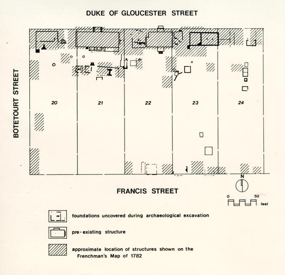 Figure 3
To the rear of the kitchen and other adjacent outbuildings is located a simple four-square kitchen garden, typical of the period, with flanking necessary houses in conventional locations. Small fruit trees and berries have been planted on either side of the kitchen garden and representative field crops occupy a lot adjacent to Botetourt Street. Mr. Wetherburn's estate listed an inventory of livestock, including six horses, four cows, and seventeen sheep. The stable yard and paddock at the rear of the lot have been developed to reflect this activity, and future plans call for the present stable, reconstructed earlier as a four-car garage, to be fully completed and furnished as an exhibition stable.(Waite 1968:22.)
Although the 1935 trenching failed to reveal any structural remains on Wetherburn's portion of Block 20, this is not necessarily an accurate conclusion. Prior to 1957, the primary focus of archaeological excavation was to locate buildings for reconstruction. The form of excavation taken, usually the digging of trenches as 45 degree angles to street and property lines, was not successful in locating certain types of structural remains. Buildings with intact or partially intact brick foundations were normally located with no trouble. Structures using more impermanent types of building techniques, such as post-in-the-ground construction, were usually missed. This was demonstrated most recently in the 1985/6 excavations at Shield's Tavern. Two 18th century structures were located in an area which had previously been cross-trenched in the 1950s and declared void of structural remains. One of these buildings was of post construction, while the other was evident only through the presence of a trench for robbed foundation walls (Higgins, personal communication). It is interesting to note that these two buildings were found in an area which had been shown on the Frenchman's Map as containing a structure. Therefore, it is not safe to conclude, on the basis of cross-trenching results, that there is no potential for archaeological remains on lots which have been previously examined.
While prospects appear good for the presence of 18th century structural remains on Colonial Lot 20 based on map and former archaeological coverage, the effects of activities occurring during the 19th and 20th centuries on Colonial Lots 20 and 21 must not be overlooked. There are indications that the rear yard was plowed during the 19th and early 20th centuries (Waite 1968:21). Numerous buildings also stood on these two lots. Photographs taken during the late 1920s show a line of buildings standing on Colonial Lot 21, along the boundary between lots 20 and 21. A 1964 memo shows that there were eleven buildings labeled as "modern" which were to be removed from this area, south of Wetherburn's Tavern (Frank 1964). There were also buildings located along the edge of South Botetourt Street. Photographs taken in 1932 reveal that these buildings were storage sheds or barns of some type, of frame construction and set on wooden and brick piers (Figure 4). These buildings were not shown on the 1921 Sanborn Map; at this point it is not apparent whether they were not standing in 1921, or more likely, if they were not insured against fire damages. It is not known when these buildings were destroyed.
These 19th and 20th century buildings most likely will not have greatly disturbed 18th century archaeological remains on Lots 20 and 21. They all appear to have been set on small piers, which were likely not set more than one foot or more into the ground. Installing these piers would have caused a minimum of ground disturbance. The same holds for the current reconstruction of the stable; it rests on a shallow brick foundation. More damaging to archaeological remains, however, would be the effects of plowing in this area. Although remains of structures would be visible through postholes which cut into the subsoil, less tangible information would be lost, such as the positions of walkways, activity areas, and certain types of dating evidence. If this area is found through testing to have been plowed, it may be more feasible to machine strip the plowzone to reveal those features which cut through subsoil.
Three budgets have been prepared for testing at Wetherburn's Stable. The first budget covers the cost of limited testing to determine if plowing has occurred in the area around the stable. This in turn will determine what excavation strategies are feasible for archaeologically investigating a 50' x 50' area around the stable. Two budgets are given for excavation, one based on machine stripping of a plowzone, and the other based on manual excavation of the same area.
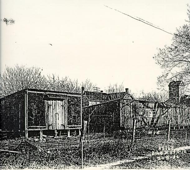 Figure 4
Bibliography
- 1935
- Tarpley's Store, Block 9, No. 41A. Colonial Lot No. 20. Unpublished manuscript report on file at the Foundation Library, Colonial Williamsburg Foundation, Williamsburg, VA.
- 1932
- Archaeological and Research Key Map of Restoration Area, Williamsburg, Virginia, Williamsburg Restoration for Williamsburg Holding Corporation. Copy on file at the Office of Archaeological Excavation, Colonial Williamsburg Foundation, Williamsburg, VA.
- 1935
- Archaeological Survey of Foundations on Block 9. Colonial Lot No. 20. Block 9, Area C. Scale ¼" = 1.0" Map on file at Architectural Archives, Colonial Williamsburg Foundation, Williamsburg, VA.
- 1782
- Carte des Environs de Williamsburg en Virginie on les Armees Francoise et Americaine ont Campes en Septembre 1781. [By] Desandrouins Armee de Rochambeau, 1782. Source: Library of Congress, Rochambeau Map #51.
- 1964
- Memo to Mrs. E. Stubbs, dated October 30, 1964. Filed in Archives Department, Block 9, #31, Bland-Wetherburn Outbuildings. Colonial Williamsburg Foundation, Williamsburg, VA.
- 1781
- Plan de la ville et environs de Williamsburg en Virginnie. 11 Mai 1781. Original on file at Special Collections, Earl Gregg Swem Library, College of William and Mary, Williamsburg, VA.
- 1974
- Wetherburn's Tavern. Revised list of owners and occupants, 1738-1780. Unpublished report on file at Foundation Library, Colonial Williamsburg Foundation, Williamsburg, VA.
- 1986
- Personal Communication, July 18, 1986.
- 1941
- Memo to Mr. Chorley, dated October 9, 1941. Filed in Archives Department, Block 9— 1941, 1946. Colonial Williamsburg Foundation, Williamsburg, VA.
- 1946
- Letter to Virginia Haughwout, dated July 8, 1946. Filed in Archives Department, Block 9— 1941, 1946. Colonial Williamsburg Foundation, Williamsburg, VA.
- 1976
- Memo to Mr. Buchanan re Wetherburn's Stable, dated July 15, 1976. On file at Archives, Block 9, # 31, Mr. Wetherburn's Tavern-outbuildings. Colonial Williamsburg Foundation, Williamsburg, VA.
- 1971
- Memo to Mr. Mahone, dated May 18, 1971. Filed in Archives Department, Block 9, # 31, Mr. Wetherburn's Tavern-Outbuildings. Colonial Williamsburg Foundation, Williamsburg, VA.
- 1969
- Archaeology and Wetherburn's Tavern. Williamsburg Archaeological Series No. 3. Colonial Williamsburg Foundation, Williamsburg, VA.
- 1965
- "Mr. Wetherburn's Tavern, Block 91 Colonial Lots 20 & 21". Manuscript report on file at Colonial Williamsburg Foundation, Williamsburg Va.
- 1968
- Mr. Wetherburn's Tavern, Block 9, Building 31. Summary Architectural Report. Unpublished report on file at Foundation Library, Colonial Williamsburg Foundation, Williamsburg, VA.
July 22, 1986
To: Conny GraftFrom: Patricia Samford
Subject: Wetherburn's Stable Briefing
I have worked up what I have been able to locate on Wetherburn's Stable into a short briefing. As my diggings have indicated, and as I'm sure you already know, Wetherburn's Stable appears to have been constructed largely on the basis of its presence on the Frenchman's Map and mention in a 1760 inventory. Previous archaeological excavations on Colonial Lots 20 and 21 were not able to locate a structure which could be interpreted as a stable. I feel, however, that the excavations done on the southern portions of Colonial Lots 20 and 21 were far from comprehensive and that this area would benefit from additional archaeological research. I have included a series of testing and excavation budgets for you to examine. Please call if you have any questions.
pms